Heavy rains put Tana River and coastal communities at risk
Rising River Tana levels and coastal flooding expose households, farms and transport routes in Tana River and Lamu to further disruption.
Reported · Published
FLOODING DISPLACES HOUSEHOLDS IN TANA RIVER AND LAMU
Heavy rainfall has triggered flooding in Tana River and Lamu counties, leaving hundreds of households displaced and thousands more affected as water levels rise across the Tana River basin.
According to the Kenya Red Cross Society (KRCS), 302 households had been displaced and a further 3,156 households affected by 31 October 2026. Tana Delta Sub-County was identified as the worst-hit area after Tulu and Minjila dams overflowed, sending water into nearby villages and residential areas.
Flooding had also spread into neighbouring Lamu County, particularly Hindi and Witu, where residential properties were experiencing rising water levels.
The Kenya Red Cross reported that 175 of the 302 displaced households had received food rations, tarpaulins and blankets through government and humanitarian assistance, while response teams continued assessing needs among affected families.
The scale of the reported impact highlights the exposure of low-lying settlements to flooding from overflowing water bodies and increased river flows.
RIVER TANA RISES AS DOWNSTREAM COMMUNITIES FACE FLOOD EXPOSURE
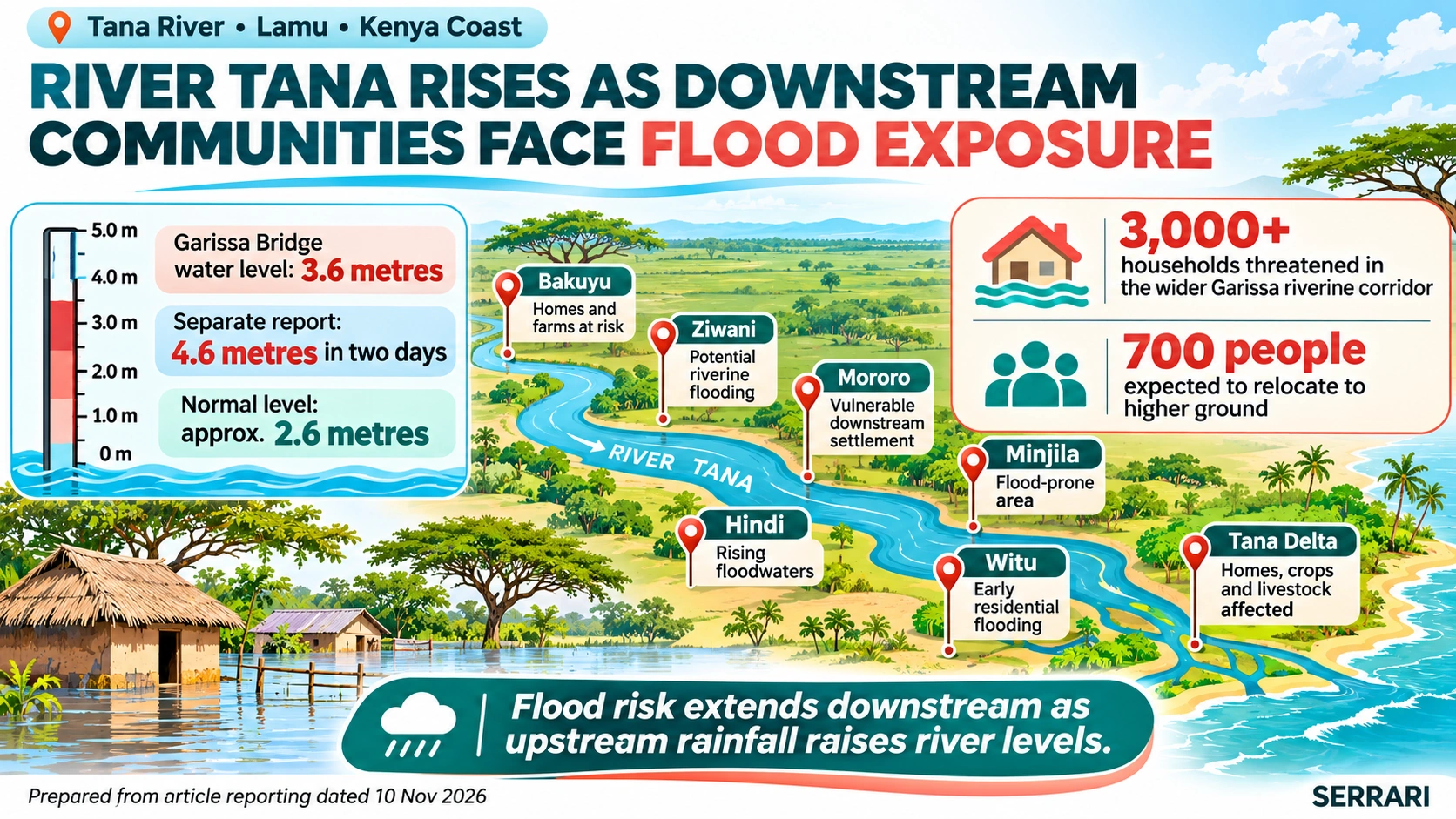
The rising River Tana presents an additional concern for communities living along its banks, particularly in areas where households depend on farming and livestock keeping.
A Daily Nation report published on 5 November indicated that water levels at Garissa Bridge had reached 3.6 metres on Monday, with further upstream rainfall expected to increase the risk of flooding.
Kenya Red Cross officials warned that the situation would become more concerning if water levels reached four metres.
A separate report by The Star on 5 November indicated that the river had risen to 4.6 metres within two days, compared with a normal level of approximately 2.6 metres at the reported monitoring point.
The reports identify several communities exposed to rising water levels:
| Location | Reported concern |
|---|---|
| Bakuyu, Tana River | Rising river water threatening homes and farms |
| Ziwani, Tana River | Exposure to potential riverine flooding |
| Mororo, Tana River | Identified as a vulnerable downstream settlement |
| Tana Delta | Flooding affecting homes, crops and livestock |
| Minjila | Identified as a flood-prone area |
| Hindi, Lamu | Residential properties affected by rising floodwaters |
| Witu, Lamu | Early flooding reported in residential areas |
The Daily Nation also reported that more than 3,000 households living along the riverine corridor in the wider Garissa area were threatened by rising water levels.
The Star reported that at least 700 people living along the flood-prone River Tana were expected to relocate to higher ground as authorities intensified preparedness measures.
These developments show that the flood risk extends beyond locations experiencing direct rainfall. Communities downstream may also face rising water levels because of rainfall and increased water flows originating upstream.
UPSTREAM RAINFALL AND SEVEN FORKS DAM RELEASES ADD TO THE RISK
The Tana River flooding situation is closely linked to rainfall within the wider river catchment.
Heavy rainfall in the Mount Kenya and Aberdare catchment areas can increase water flowing into the Tana River system, affecting communities located further downstream.
The Seven Forks hydroelectric dam cascade is another important factor in the current situation.
According to reporting by Daily Nation, Water, Sanitation and Irrigation Cabinet Secretary Eric Mugaa warned that controlled water releases from the Seven Forks reservoirs would become necessary once storage capacity limits were reached.
The releases are intended to protect the dams from damage. However, increased water volumes entering downstream channels can create flooding risks, particularly where river channels cannot accommodate the additional flow.
Kenya Electricity Generating Company (KenGen) has also urged residents living along the Tana River and downstream from its hydroelectric dams to relocate to safer areas.
The company warned that households, farms and other structures established close to riverbanks could be exposed when reservoir inflows increase and excess water is released through dam spillways.
This makes upstream rainfall monitoring and communication about reservoir levels important for communities downstream.
NOVEMBER RAINFALL OUTLOOK INCREASES CONCERN FOR COASTAL COUNTIES
The Kenya Meteorological Department (KMD) forecast above-average rainfall across more than 40 counties during November 2026.
The November monthly forecast identifies several coastal counties among areas expected to receive rainfall above their long-term averages, including:
- Tana River.
- Mombasa.
- Kilifi.
- Kwale.
- Lamu.
The department warned that enhanced rainfall could increase the risk of flash floods, riverine flooding, landslides and infrastructure damage.
Its forecast also highlighted particular exposure in flood-prone areas, low-lying coastal locations and urban centres with poor drainage.
A weekly forecast covering 3–10 November also identified Tana River and the coastal counties among areas expected to receive rainfall.
The forecast signals are relevant because the region is already experiencing flooding in some communities. Additional rainfall could increase pressure on river systems, drainage infrastructure and households located in low-lying areas.
However, the seasonal and monthly forecasts should not be interpreted as confirmation that every coastal county will experience flooding.
COASTAL EXPOSURE EXTENDS BEYOND RIVER FLOODING
Flood risks along the Kenyan coast are not limited to the Tana River system.
The Kenya Maritime Authority (KMA) issued an advisory warning of rough sea conditions, strong winds, high waves, heavy rainfall and reduced visibility along the coast between September and December 2026.
The warning covered Mombasa, Kwale, Kilifi and Lamu counties.
The authority cautioned that high waves and strong winds could create risks for fishing vessels, boat operators and other maritime users. Surging waves during high tides could also affect low-lying coastal areas.
Fisherfolk and boat operators were advised to monitor official weather and maritime updates, secure vessels properly and avoid venturing into the sea when conditions become unsafe.
This adds a maritime safety dimension to the wider coastal weather outlook, particularly for communities whose livelihoods depend on fishing and other sea-based activities.
Context is everything. Stay ahead of shifting trends with today’s market updates, and uncover emerging opportunities using the Serrari Group Market Index and Marketplace. Then, take control of your own financial future by exploring our Money & Life Reset Transformation Blueprint ™ to build stronger habits, create better systems, and design a path toward lasting wealth.
ECONOMIC, LIVELIHOOD AND PUBLIC HEALTH IMPLICATIONS
Flooding across Tana River and coastal communities could affect households through displacement, damage to agricultural production, disruption of transport and increased public health risks.
The impacts already reported in Tana Delta demonstrate how flooding can affect several aspects of community livelihoods simultaneously.
| Sector | Reported or potential impact |
|---|---|
| Housing | Residential properties submerged or surrounded by floodwater |
| Agriculture | Crops affected or destroyed by flooding |
| Livestock | Livestock exposed to floodwaters and displacement |
| Household income | Disruption of farming and other livelihood activities |
| Sanitation | Damaged toilets and sanitation facilities |
| Public health | Potential contamination of water sources and waterborne disease risks |
| Transport | Roads and access routes exposed to flooding and disruption |
| Fisheries and maritime activity | Rough seas, strong winds and high waves affecting fishing and navigation |
Agricultural livelihoods and food security
Agriculture is an important source of income and food for communities along the Tana River.
The Daily Nation reported that flooding had affected crops and livestock in parts of Tana Delta, leaving some families struggling after losing sources of food and income.
FEWS NET's September 2026–January 2027 Kenya outlook also identified flooding as a risk to livelihoods and food access in Tana River and Lamu.
The organisation projected that flooding could damage roads, restrict the movement of people and goods, disrupt food and livestock markets, displace households and constrain access to essential services.
In Lamu, flooding within the Tana River Delta was expected to affect food production and income-earning opportunities.
These developments could compound existing food insecurity among vulnerable households.
Sanitation and public health
Flooding also creates sanitation challenges when toilets are submerged or destroyed and water sources become contaminated.
In Tana Delta, residents reported damage to sanitation facilities, raising concerns about exposure to waterborne diseases.
KMD has also warned that stagnant water associated with enhanced rainfall could create favourable mosquito-breeding conditions in susceptible areas.
The combination of contaminated water sources, damaged sanitation infrastructure and disrupted access to essential services makes public health preparedness an important part of the flood response.
Transport and infrastructure
Flooding can affect the movement of people, food supplies and essential services.
FEWS NET identified potential road damage and restricted movement as concerns in flood-exposed areas of eastern Kenya.
For communities dependent on road access to markets, healthcare facilities and other services, prolonged flooding could increase the difficulty of obtaining essential supplies.
EARLY WARNING AND PREPAREDNESS MEASURES
Authorities and humanitarian organisations have stepped up preparedness measures as water levels rise along the Tana River.
In Garissa, county authorities have activated emergency operations arrangements and identified evacuation sites for potentially affected populations.
The Kenya Red Cross has pre-positioned response boats and emergency supplies in strategic locations to support evacuation and relief distribution.
Public awareness campaigns are also being conducted through local administrators, public meetings, vernacular radio stations and bulk SMS messages.
KenGen has urged communities living near riverbanks and downstream from its dams to move to higher ground.
For households in flood-prone areas, the immediate priorities include:
- Following evacuation instructions issued by county and national authorities.
- Moving people, livestock and essential belongings to safer, higher ground when instructed.
- Avoiding crossing swollen rivers and moving floodwaters.
- Keeping away from riverbanks when water levels are rising.
- Monitoring official weather and flood updates.
- Protecting drinking water from contamination.
- Seeking assistance through local authorities and humanitarian response teams.
The Kenya Meteorological Department's weather warnings page should also be monitored for changes in official alerts.
Current alert status: At the time of research on 10 November 2026, KMD's online weather-warnings page displayed no active alerts. Its listed coastal heavy-rainfall advisory issued on 24 October had expired. The absence of an active alert does not mean that previously affected communities are no longer exposed to flooding or that river levels have returned to normal.
OUTLOOK
The flooding affecting Tana River and parts of the coast illustrates the combined risks of heavy rainfall, upstream river inflows, dam storage conditions and settlement exposure along flood-prone waterways.
The displacement of 302 households and the reported impact on a further 3,156 households in Tana Delta demonstrate that the situation has already moved beyond a forecast-stage concern.
Rising River Tana levels add further exposure for communities in Bakuyu, Ziwani and Mororo, while the possibility of controlled releases from the Seven Forks reservoirs makes downstream monitoring particularly important.
The November rainfall outlook also identifies Tana River, Mombasa, Kilifi, Kwale and Lamu among counties expected to receive above-average rainfall. This increases the importance of monitoring rainfall developments alongside river levels and dam conditions.
Beyond immediate displacement, the wider implications include agricultural losses, disruption to transport and markets, sanitation challenges and increased public health risks.
The key developments to monitor are rainfall across the Mount Kenya and Aberdare catchments, River Tana water levels, Seven Forks reservoir releases, flood conditions in Tana Delta and Lamu, and evacuation and relief operations.
For exposed communities, timely communication and early movement to safer ground remain central to reducing the risk of further displacement and loss of life.
SOURCES
- Kenya Meteorological Department (KMD) – November 2026 Monthly Weather Forecast. Source for the November rainfall outlook and national weather-related risks.
- Kenya Meteorological Department (KMD) – Official Weather Warnings. Source for the status of official weather alerts.
- Daily Nation – Coastal floods displace hundreds as Tana River and Lamu brace for more water, 31 October 2026. Source for household displacement, affected households, dam overflow and downstream flood risks.
- Daily Nation – Residents warned of flooding as River Tana swells, 5 November 2026. Source for rising river levels, affected communities and flood exposure in Tana Delta.
- The Star – Heavy rains displace 302 households in Tana River, 30 October 2026. Source for Kenya Red Cross displacement figures and flooding in Tana Delta and Lamu.
- The Star – Families urged to seek high ground as River Tana swells, 5 November 2026. Source for river-level developments, relocation preparations and exposed settlements.
- Kenya Broadcasting Corporation (KBC) – Brace for above-average rainfall in November – Kenya Met, 1 November 2026. Source for the November rainfall forecast and associated flood risks.
- The Star – Heavy rains to lash several counties as Met warns of flooding, 4 November 2026. Source for the weekly rainfall outlook covering 3–10 November 2026.
- People Daily – El Niño: KenGen urges residents near Tana River dams to move to safer areas, 2 November 2026. Source for KenGen's downstream safety advisory and Seven Forks dam-related risks.
- Government Advertising Agency / Kenya News Agency – KMA warns of rough seas along the coast, 29 September 2026. Source for coastal maritime warnings concerning strong winds, high waves, heavy rainfall and reduced visibility.
- FEWS NET – Gains expected from short rains, but flooding threatens recovery in eastern Kenya, September 2026. Source for projected flooding impacts on food security, livelihoods, transport and essential services in Tana River and Lamu.
Your financial future isn’t something you wait for—it’s something you build. The real question is: when do you begin?
Move beyond simply staying informed. Navigate the markets with clarity—track trends through the Serrari Group Market Index, uncover opportunities in the Serrari Marketplace, and build practical knowledge with our Curated Wealth Builder Platform.
Stay connected to what truly matters. Get daily insights on macro trends and financial movements across Kenya, Africa, and global markets—delivered through the Serrari Newsletter.
Growth opens doors. Advance your career through professional programs including ACCA, HESI A2, ATI TEAS 7 , HESI EXIT , NCLEX - RN and NCLEX - PN, Financial Literacy!🌟—designed to move you forward with confidence.
See where money is flowing—clearly and in real time. Track Money Market Funds, Treasury Bills, Treasury Bonds, Green Bonds, and Fixed Deposits, alongside global and African indexes, key economic indicators, and the evolving Crypto and stablecoin landscape—all within Serrari’s Market Index.