El Niño 2026/27: A strengthening climate event set to reshape global weather patterns
A strengthening El Niño brings contrasting rainfall, cyclone and water-supply risks across regions, with implications for agriculture, energy and ecosystems.
Reported · Published
EL NIÑO STRENGTHENS AS GLOBAL CLIMATE RISKS INCREASE
The 2026/27 El Niño event is continuing to strengthen, with forecasts from the World Meteorological Organization (WMO) and the National Oceanic and Atmospheric Administration (NOAA) pointing to a strong-to-very-strong event extending into early 2027.
WMO's Global Seasonal Climate Update, published on 21 October 2026, projects that the seasonal average Niño 3.4 sea-surface temperature anomaly could reach approximately +3.8°C during November 2026–January 2027, with the warming trend expected to peak around December.
NOAA's Climate Prediction Center, in its 8 October ENSO Diagnostic Discussion, reported a Niño 3.4 anomaly of +2.1°C and indicated a greater than 83% probability of strong-to-very-strong El Niño conditions continuing through January–March 2027.
The two figures represent different reporting periods and forecast products. They should not be interpreted as simultaneous measurements.
The developing event is raising concerns about shifting rainfall patterns, unusually high temperatures, drought risks and flooding across different parts of the world. Its implications extend to agricultural production, water availability, energy generation, ecosystems and economic activity.
GLOBAL CLIMATE INDICATORS
The latest WMO and NOAA assessments point to an unusually strong warming signal in the tropical Pacific.
Key indicators
| Indicator | Latest reported information |
|---|---|
| Climate status | El Niño Advisory |
| NOAA assessment | Strong-to-very-strong El Niño likely |
| NOAA Niño 3.4 observation | +2.1°C in its October 2026 diagnostic assessment |
| NOAA forecast | Greater than 83% probability of strong-to-very-strong conditions through January–March 2027 |
| WMO seasonal projection | Approximately +3.8°C Niño 3.4 anomaly for November 2026–January 2027 |
| Expected peak | Around November–December 2026, with WMO's October update indicating December |
| Potential duration | Influence expected to extend into 2027 |
The strength of the developing event is a significant indicator, but it does not establish that every region will experience severe weather. El Niño's effects vary geographically and depend on regional climate conditions and other atmospheric drivers.
The distinction between the strength of the climate event and the severity of its impacts is important when interpreting the seasonal forecasts.
REGIONAL WEATHER OUTLOOK: WHERE THE MAIN RISKS ARE EMERGING
The developing El Niño is expected to produce contrasting rainfall patterns across different regions. The latest seasonal assessments point to increased rainfall and flooding risks in parts of East Africa, while other areas face rainfall deficits, water shortages and drought concerns.
Africa
Greater Horn of Africa — Increased rainfall and flooding risks
Countries including Kenya, Somalia, Ethiopia, Uganda, Tanzania, Burundi and Rwanda are facing increased chances of above-average rainfall during the October–December 2026 rainy season.
The regional forecast developed by the IGAD Climate Prediction and Applications Centre (ICPAC) indicates particularly high probabilities of enhanced rainfall over parts of southern Ethiopia, central and southern Somalia and northeastern Kenya.
The expected wetter conditions could improve water availability and pasture conditions, supporting agricultural production and livestock. However, excessive rainfall could create significant disruption.
Potential consequences include:
- Increased river levels and flash flooding.
- Flooding in low-lying agricultural areas.
- Damage to roads, bridges and other infrastructure.
- Improved water availability and pasture conditions.
- Increased risks of waterborne diseases.
The regional outlook therefore presents two competing considerations: improved rainfall could benefit agriculture and livestock, while excessive rainfall could result in crop destruction, infrastructure damage and public health risks.
Southern Africa — Rainfall deficits and drought concerns
Southern Africa requires close monitoring because El Niño is historically associated with reduced rainfall across several parts of the region.
WMO's South-West Indian Ocean outlook for November 2026–January 2027 identifies:
- Below-normal rainfall in southern and central Mozambique.
- Below-normal rainfall in parts of western Madagascar.
- Normal to below-normal rainfall in parts of South Africa and southern Madagascar.
These conditions could increase pressure on agricultural production, water resources and hydropower generation.
The contrast between the wetter outlook in parts of the Greater Horn of Africa and rainfall deficits across parts of Southern Africa highlights the uneven geographical distribution of El Niño's effects.
Asia and the Western Pacific
The Western Pacific is expected to experience significant rainfall changes during November 2026–January 2027.
According to WMO's 5 November 2026 regional update, below-normal rainfall is likely across:
- Palau.
- Marshall Islands.
- Central and southern Papua New Guinea.
- Southern French Polynesia.
In contrast, above-normal rainfall is expected from Nauru to eastern Kiribati.
The outlook is particularly important for countries already experiencing water supply pressures. Papua New Guinea, Solomon Islands, Vanuatu, Fiji and Tonga had reported water shortages associated with persistent rainfall deficits between May and October 2026.
Higher temperatures could intensify drought conditions in areas where El Niño typically brings reduced rainfall.
Marine heatwave and coral reef exposure
WMO also forecasts strong to extreme marine heatwaves around eastern Kiribati. Coral reefs in central and eastern Kiribati face a risk of bleaching extending into February 2027.
This adds an environmental dimension to the regional outlook, with potential pressure on marine ecosystems alongside the risks to water availability.
North America
WMO's October seasonal outlook identified increased chances of above-normal rainfall across parts of North America south of 45°N.
El Niño can influence the position and strength of the jet stream, affecting winter storm tracks and precipitation patterns.
The seasonal outlook has implications for:
- Winter rainfall and snowfall distribution.
- Flooding risks in some areas.
- Agricultural growing conditions.
- Heating and energy demand.
These signals indicate possible changes in seasonal conditions. They should not be interpreted as predictions of individual storms, snowfall events or specific flooding incidents.
South America
South America is expected to experience contrasting rainfall patterns as El Niño influences regional weather conditions.
WMO's October 2026 outlook identified increased chances of above-normal rainfall in southeastern South America, while northwestern South America was among the areas with an increased likelihood of below-normal rainfall.
The potential implications include:
- Flooding and rising river levels in wetter areas.
- Agricultural disruption in regions experiencing rainfall deficits.
- Changes in hydropower availability.
- Pressure on water supplies and ecosystems.
The geographical distribution and timing of rainfall will be important in determining the extent of these impacts.
Europe
El Niño's influence on European weather is generally less direct and less consistent than in some tropical regions.
Its effects can be influenced by the North Atlantic Oscillation and other atmospheric circulation patterns. Consequently, individual European winter weather events should not automatically be attributed to El Niño.
The key areas to monitor include:
- Winter temperature anomalies.
- Precipitation and snowfall patterns.
- Storm activity.
- River levels and drought conditions.
For Europe, continued observation of regional atmospheric circulation and seasonal forecasts will be important in assessing the extent of any El Niño-related influence.
Context is everything. Stay ahead of shifting trends with today’s market updates, and uncover emerging opportunities using the Serrari Group Market Index and Marketplace. Then, take control of your own financial future by exploring our Money & Life Reset Transformation Blueprint ™ to build stronger habits, create better systems, and design a path toward lasting wealth.
TROPICAL CYCLONE ACTIVITY: CONTRASTING OUTLOOKS ACROSS OCEAN BASINS
El Niño can influence tropical cyclone activity by changing atmospheric circulation, wind shear and oceanic conditions. The 2026/27 seasonal outlooks indicate different levels of expected activity across the South-West Indian Ocean and South-West Pacific.
South-West Indian Ocean — Below-normal activity expected
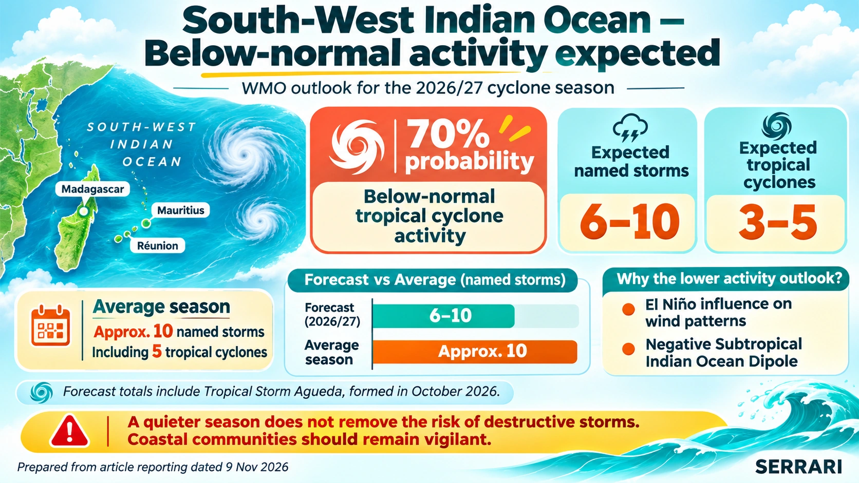
In an update published on 5 November 2026, WMO reported a 70% probability of below-normal tropical cyclone activity in the South-West Indian Ocean during the 2026/27 season.
The outlook forecasts:
| Indicator | 2026/27 outlook |
|---|---|
| Probability of below-normal activity | 70% |
| Expected named storms | 6–10 |
| Expected tropical cyclones | 3–5 |
| Average season | Approximately 10 named storms, including 5 tropical cyclones |
The forecast totals already include Tropical Storm Agueda, which formed in October 2026.
The expected reduction in activity is associated with the influence of El Niño on wind patterns, alongside a negative Subtropical Indian Ocean Dipole.
However, a below-average cyclone season does not eliminate the possibility of a destructive storm. WMO has cautioned that communities must remain vigilant even when seasonal activity is expected to be lower than normal.
South-West Pacific — Normal-to-above-normal activity
The South-West Pacific presents a different outlook.
WMO expects normal-to-above-normal tropical cyclone activity between November 2026 and April 2027.
A more active season than usual is likely near and east of the International Date Line, while normal or below-normal activity is forecast farther west.
Despite the regional differences, severe cyclones remain possible.
The contrasting outlooks demonstrate why cyclone assessments need to be considered by individual ocean basin rather than treating El Niño as producing one uniform global cyclone response.
ECONOMIC AND ENVIRONMENTAL EXPOSURE
The potential effects of the developing El Niño extend beyond weather conditions. Changes in rainfall and temperature could affect economic activity, natural resources, infrastructure and ecosystems.
| Sector | Potential implications |
|---|---|
| Agriculture | Crop losses resulting from flooding, drought and irregular rainfall |
| Energy | Reduced hydropower availability in drought-affected regions |
| Water resources | Water shortages in dry regions and flooding in wetter areas |
| Food markets | Changes in crop production and food supply |
| Transport | Damage to roads, railways and ports from extreme weather |
| Public health | Greater exposure to heat stress and waterborne diseases |
| Ecosystems | Pressure on forests, wetlands, marine ecosystems and coral reefs |
| Insurance | Increased exposure to weather-related property and agricultural losses |
Energy and hydropower
Energy production is particularly exposed in countries that depend heavily on hydropower. Reduced rainfall and declining reservoir levels could limit electricity generation in drought-affected regions.
Conversely, flooding could damage energy infrastructure and interrupt electricity distribution.
Agriculture and food supply
Changes in rainfall distribution could affect crop production in both wetter and drier regions. Excessive rainfall may damage crops and agricultural infrastructure, while prolonged rainfall deficits could reduce yields and increase pressure on water supplies.
These disruptions could influence food availability and agricultural income.
Water resources and public health
Regions experiencing rainfall deficits could face increased pressure on water supplies. In wetter areas, flooding may damage infrastructure and increase exposure to waterborne diseases.
Higher temperatures could add to heat-related health risks, particularly in regions already experiencing dry conditions.
Marine ecosystems
The forecast marine heatwaves around eastern Kiribati present an additional environmental concern. Coral bleaching risks extending into February 2027 could place pressure on marine ecosystems.
OUTLOOK: EL NIÑO'S INFLUENCE INTO 2027
El Niño is not a permanent climate condition. It eventually weakens and may transition into ENSO-neutral conditions or La Niña.
However, the weakening of the event does not necessarily mean that all its effects disappear immediately. Changes in ocean temperatures, atmospheric circulation and regional rainfall can persist beyond the peak.
As of 9 November 2026, the available WMO and NOAA assessments indicate that El Niño is likely to remain influential into 2027.
NOAA's next ENSO Diagnostic Discussion is scheduled for 12 November 2026. The update is expected to provide a further assessment of whether observed oceanic and atmospheric conditions continue to support the existing forecast.
The key developments to monitor are:
- Changes in the Niño 3.4 sea-surface temperature anomaly.
- Updated WMO and NOAA assessments of event strength and duration.
- Regional rainfall and temperature forecasts.
- Flood and drought risks across affected regions.
- Tropical cyclone activity across the Indian and Pacific Ocean basins.
- Water availability, agricultural conditions and hydropower exposure.
Regional and national meteorological agencies will remain important in translating global seasonal signals into more specific local forecasts.
ANALYST DESK ASSESSMENT
The 2026/27 El Niño event is developing into a major global climate concern, with WMO and NOAA assessments indicating the possibility of a very strong event peaking towards the end of 2026.
The regional outlooks reveal that the main risk is not uniform global warming or a single worldwide weather pattern, but the uneven distribution of rainfall and temperature changes.
The Greater Horn of Africa faces increased rainfall and flooding risks, while parts of Southern Africa are exposed to rainfall deficits. The Western Pacific faces continued water supply concerns, alongside marine heatwave and coral bleaching risks around Kiribati.
The cyclone outlook also differs by ocean basin. Below-normal activity is expected in the South-West Indian Ocean, while normal-to-above-normal activity is forecast in the South-West Pacific.
These developments have implications for agriculture, water security, energy generation, transport infrastructure, public health and ecosystems.
The strength of El Niño increases the likelihood of characteristic climate impacts, but does not guarantee that every region will experience extreme weather. Regional forecasts and updated observations remain essential for assessing where the greatest exposure will occur.
For the November 2026–January 2027 period, the key areas requiring continued attention are rainfall distribution, temperature anomalies, water availability, agricultural conditions and tropical cyclone activity.
SOURCES
The report draws on the following institutional assessments, seasonal forecasts and regional climate updates:
- World Meteorological Organization (WMO) — Global Seasonal Climate Update for November–December–January 2026, published 21 October 2026. Source for the global seasonal climate outlook and the projected +3.8°C Niño 3.4 anomaly.
- National Oceanic and Atmospheric Administration (NOAA), Climate Prediction Center — ENSO Diagnostic Discussion, 8 October 2026. Source for the El Niño Advisory, +2.1°C Niño 3.4 observation and probability assessment for strong-to-very-strong conditions.
- WMO — WMO Global Seasonal Climate Outlook Informs Humanitarian Action, 26 October 2026. Source for regional climate risk context and the implications of the developing El Niño.
- IGAD Climate Prediction and Applications Centre (ICPAC) — Summary for Decision Makers: October to December 2026 Season, September 2026. Source for the Greater Horn of Africa rainfall outlook.
- WMO — El Niño Impacts Greater Horn of Africa, 19 August 2026. Source for the regional outlook and potential rainfall-related impacts across East Africa.
- WMO — Western Pacific Faces Drier Months as El Niño Strengthens, 5 November 2026. Source for the Western Pacific rainfall outlook, existing water shortages, marine heatwaves and South-West Pacific cyclone outlook.
- WMO — El Niño Favours Quieter South-West Indian Ocean Cyclone Season, 5 November 2026. Source for the 2026/27 South-West Indian Ocean cyclone activity forecast and associated regional rainfall outlook.
Your financial future isn’t something you wait for—it’s something you build. The real question is: when do you begin?
Move beyond simply staying informed. Navigate the markets with clarity—track trends through the Serrari Group Market Index, uncover opportunities in the Serrari Marketplace, and build practical knowledge with our Curated Wealth Builder Platform.
Stay connected to what truly matters. Get daily insights on macro trends and financial movements across Kenya, Africa, and global markets—delivered through the Serrari Newsletter.
Growth opens doors. Advance your career through professional programs including ACCA, HESI A2, ATI TEAS 7 , HESI EXIT , NCLEX - RN and NCLEX - PN, Financial Literacy!🌟—designed to move you forward with confidence.
See where money is flowing—clearly and in real time. Track Money Market Funds, Treasury Bills, Treasury Bonds, Green Bonds, and Fixed Deposits, alongside global and African indexes, key economic indicators, and the evolving Crypto and stablecoin landscape—all within Serrari’s Market Index.